Table of Contents
- Details 11 Famous Geoje Mountains
- The Best View Comes After The Hardest Climb
- Starting Points: 11 Geoje Mountains
- Daegumsan (Mt. Daegeum)
- Gyeryongsan (Mt. Gyeryong)
- Mangsan (Mt. Mang)
- Oknyeobong (Oknyeo Peak)
- Bukbyeongsan (Mt. Bukbyeong)
- Aengsan (Mt. Aeng)
- Garasan (Mt. Gara)
- Seonjasan (Mt. Seonja)
- Nojasan (Mt. Noja)
- Sanbangsan (Mt. Sanbang)
- Guksabong (Guksa Peak)
- Geoje Mountain Tips
- Don't Miss a Beat!
- Success!
Details 11 Famous Geoje Mountains
Great places for a hike, family travel or just the ultimate place to take travel photographs.
“The Human Spirit Needs Places Where Nature Has Not Been Rearranged By The Hand Of Man”
Now you are ready to hike the Geoje Mountains but do not know where to start. Here are a few details on each mountain to help you get started that have been provided by the Geoje Tourist Resources Book and from my own hiking experiences with friends. Hope you enjoy these hikes as much as I have. Our time here is short on Geoje so hurry and start your hiking. Remember there are numerous starting points. These Geoje Mountains details are just guidelines to get you started.
Starting Points: 11 Geoje Mountains
Daegumsan (Mt. Daegeum)
Mt. Daegeum is located at the northern end of Geoje with an altitude of 437.5 meters. Another name known by is “Great Iron”. It produced iron during the Silla Dynasty. From the summit on a clear day one can see Japan’s island Daemado, Busan, Jinhae, and Masan. Visit in spring and see the bright pink azaleas that roll across the entire mountain side. There are at a minimum of five trails that range from 1.6km to 4.1km hike. A great hike is to start from behind the Okpo School behind BH1 and take a hiking trail from there all the way to Mt Daegumsan. Can be done round trip or leave a car placed for your ride back home. Allow 4 plus hours one-way for this trail.
Gyeryongsan (Mt. Gyeryong)
Mt. Gyeryong is located in the center of Geoje behind the POW Camp with an altitude of 566 meters. Its name resembles a “gye” and features twisting ravines formed by the upward slithering of dragons. Rocks on this mountain hold many interesting names. Located here are the Remains of a Korean War-era communication station. Four plus trails can lead you to the peak that vary greatly in difficulty but note there are two peaks close together. One has a pagoda on it and one has the stone monument. Make sure to make it to the peak with the stone monument. Not an easy hike and you would hate to miss the monument. This is at least a 2 hour hike depending on your starting point.
Mangsan (Mt. Mang)
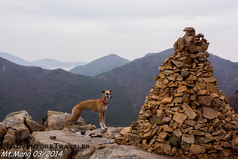
Mt. Mang is located at the southernmost tip of Geoje Island with an altitude of 397 meters. It was named from being a lookout point called “mang”. This is a place where the local people would climb to the highest point to watch out for Japanese invaders. From the peak feel the fresh air blow across your face, see the many islands, and view the Hallyeo Maritime National Park. The trails take you up and over approximately 4 mountain peaks with the stone monument at the tallest peak Mt. Mang. This is at least a 4 hour hike so pack a lunch and enjoy. Good place to park is by the ocean and climb the peak first.
Oknyeobong (Oknyeo Peak)
Mt. Oknyeobong is above Aju-dong on the eastern side of Geoje with an altitude of 554.7 meters. Its name comes from the legend of the daughter of the Great Jade Emperor. On the eastern ridge a smoke station located at the summit has a modern communication station. From the southeastern side the Korean Straight can be seen and the northeastern side DSME. A view of Okpo Bay is seen from the peak which is the site of Admiral Yi Sun-sin’s first naval victory. Find the jagged rocks to sit enjoy a quick lunch while looking out at the blues of the ocean and green leaves of the mountains. Good place to start your hike is behind the sports field in Aju-dong. Allow 2 plus hours to hike to the peak.
Bukbyeongsan (Mt. Bukbyeong)
Mt. Bukbyeong is located inland with an altitude of 465.4 meters. Receives its name from how it encircles Gohyeon, like a decorative folding screen. There are 4 trails to the peak. The hike is mostly shaded and cooler during the summer months. Stop and listen to the frogs, feel the stillness surround you and see the beautiful silver color trees during winter. A good place to start is at the Buddhist temple for a 1.5 hour hike.
Aengsan (Mt. Aeng)
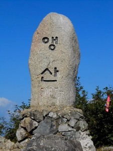
Mt. Aeng is located above the village of Yugye in Hacheong-myeon on Gohyeon Bay. The peak has an altitude of 507.4 meters. The mountain is named after the nightingale because the shape resembles a bird in flight with outstretched wings. Stones used to produce whetstone is found at the top which the locals use to sharpen knives. Good starting point is to drive towards the Bamboo Forest before Gohyeon then follow the road to the right and then take a left that leads you through another village.
Garasan (Mt. Gara)
Mt. Garasan is located at the southernmost tip near a beach. This is the highest mountain peak on Geoje with an elevation of 585 meters. Many thick growing maple trees here that change to red, yellow and orange during the autumn months. At the top find the beacon signal station which was used to watch for Japanese pirates.
Seonjasan (Mt. Seonja)
Altitude of 507 meters also known as the “fan” mountain. Must see are the leaves that turn red, yellow and orange in the fall and blooming rhododendron in the spring. Around the top of the peak is Shinseon Rock. Some believe that good health and longevity to those who pray in front of it. Good starting point to start the hike by the Geoje Art Land.
Nojasan (Mt. Noja)
Mt. Nojasan is located in the midst of Gucheon, Buchun, and Hankdong villages with an altitude of 565 meters. Known as the mountain of mystery, due to the large rare bird’s called fairy pita or palsaek (eight-color) that dwell there. From the summit one can see the mysterious islands of Dodahoe. See the altar at the top used for past ceremonies to bring much need rain. Convenient trails start in the Geoje National Forest of Recreation. My trail started from one of the inland roads outside and pass National Forest entrance going towards the ocean.
Sanbangsan (Mt. Sanbang)
Mt. Sanbangsan is located above Sanbang village with an elevation of 507.2 meters. Summit is formed by 3 distinct rocks and has a panorama view of the islands of Dadohae. Ten meters below the peak is Mujiigaeteo, rainbow place. Water dripping from the rocks formed a natural well on a rock below. Caves can be seen on the hike along with roe deer and a great lookout point called Thunder Rock. Good place to start your hike is just drive pass the Sanbangsan Biweon (Mt. Sanbangsan secret garden) and Park. Plan to hike up and over some boulders for a two hour hike through some lovely foliage.
Guksabong (Guksa Peak)
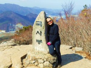
Mt. Guksabong is located overlooking Okpo Bay with an altitude of 464 meters. It consists of two peaks, with the other one called Lil Guksabong by some. The mountain gets its name from the many classical scholars from all around the nation that used to visit. From the peak one can overlook Okpo, DSME, and Gohyeon. This mountain hike is one the expats compare all other peaks too. “If you can hike Guksabong you can hike….”. Good place to start is trails behind the Admiral Hotel or the Admiral Apartments. Trails also can start or finish by the Evervill Apartments, Aju-dong, fire station, fire road and many others locations. Look for deer and wild plants like shiitake mushrooms and raspberries while on your hike or your fellow friends. Guksabong is a frequently traveled peak by all.
Geoje Mountain Tips
Now you’re wondering if you can hike the Geoje Mountains. Some will say if you can hike Mt. Guksabong you can hike these mountains. Take your time, enjoy the hike and be safe. All the peaks mentioned above are some great hikes to share with your friends. Geoje Mountains have so many hiking trails and one is capable of hiking from one peak to another. Remember too look up frequently while hiking to enjoy the surrounding views along the way. Do not forget to join the Geoje Hash group where once a month you join others on a day hike, BBQ along with some fun. On On the Geoje Hiking Group says and once you have joined visit others around the world. My name is the Tenious Turtle so look for me. Feel at peace and tranquil while taking each breath.
Etcetera
A helpful book is the Geoje Tourists Resources Book. Included are descriptions, pictures and possible hiking starting points for these Mountains. The trails are not the easiest to find in the book but is one of the few books available. Don’t forget to take along some cash in case you end your hike far away from your car. You can always catch a cab back to your starting point. Don’t forget to read the 10 Essentials items needed for your pack. Now grab a fellow hiker, decide on which mountain to hike and have fun with these details for the Geoje Mountains. Be a sensible hiker and leave no footprints 👣
See more blogs on Geoje at 1Adventure Traveler.
ALSO, PLEASE HAVE A LOOK AT THE LINK UP’S I’M PARTICIPATING IN WITH – #THEWEEKLYPOSTCARD, #FOLLOWMEFRIDAY AND #WEEKENDWANDERLUST ON FACEBOOK. HERE YOU WILL FIND FANTASTIC ADVENTURES BY OTHER PROFESSIONAL BLOGGERS.







Hi Stephanie
Where do we get hold of the book Geoje Tourists Resources Book? Is it still available?
Thanks for the info! Great work.
Hi Miranda
The “Geoje Tourists Resources Book” should still be available. It’s put out each year by the Geoje City Gov project “Blue City Geoje”.. One used to be able to pick on up in Jansangpo, but from what I heard the office has moved. The “GIC” Geoje International Center should have copies or maybe be able to help you obtain one. All it takes is a phone call and one can be mailed to you.
Another good resource guide is called the “Korea Travel Guide” and this can be picked up at train & subway stations, 7 Eleven, Lotte Mart and maybe the airport at a tourist spot. This resource guide highlights a good part of South Korea, which is a great guide.
Hope this information helps and please continue to visit 1AdventureTraveler and share your adventure comments.